History of Mount Hamilton RoadThe Naming of the Mountain
The first recorded ascent of Mount Hamilton was on Aug 26, 1861, by William H. Brewer, of the California State Geological Survey. Brewer's boss, Josiah Whitney often accompanied him on these treks, but was not present for this climb. Brewer kept a journal [reference 1], and so here is his first-hand account: Nearly east of San Jose, some distance in the mountains, is a high peak we wished to reach, being the highest in that part of the Diablo Range. As near as we could judge from our maps, we supposed it nine miles distant in a straight line. It proved over fifteen. Mr. Hamilton went with us. A ride of six miles across the plain brought us to the foot of the ridge. All this is enclosed, in farms, and under good cultivation. Farmhouses, orchards, etc., give it an American look. We then struck the ridge, and on rising, had a capital chance to see this part of the Santa Clara Valley. It is perhaps twelve or fourteen miles wide at San Jose, an almost perfect plain, very fertile, a perfect garden, and much of it in higher cultivation than any other part of California.
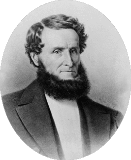
Brewer's friend, the reverend Laurentine Hamilton, accompanied him on this first ascent of the mountain. Reverend Hamilton was pastor of the First Presbyterian Church of San Jose from 1859 to 1864. He was also Superintendent of San Jose Schools from 1862 to 1864. There is a plaque at Lick Observatory that explains the naming of Mount Hamilton: In the late summer of 1861, William H. Brewer, director of field work for the California State Geological Survey, invited his long-time friend, the Reverend Laurentine Hamilton, to accompany him on a mountain-climbing expedition. Their goal was a peak judged to be the highest in the Diablo Range, thirteen miles east of San Jose. After an arduous mule ride, the party hiked the last three miles on foot. Brewer and his assistant, Charles F. Hoffman, carried heavy surveying instruments and soon fell behind. "As we neared the summit," Brewer later recalled, "Mr. Hamilton pushed on ahead of us, and reaching it, swung his hat in the air and shouted back to us: 'First on top - for this is the highest point.' " Sometime later that year, Brewer or Hoffman suggested that the mountain be called Hamilton, in honor of the Reverend Hamilton, and the name was thereupon adopted.
An Observatory for the TopIn 1874 James Lick had the idea of financing the building of an observatory. Lick's first choice of location was on his property near Lake Tahoe, but then changed his mind due to the severity of climate. Lick's second choice was Mount St. Helena, but then changed his mind again, to focus on Santa Clara County. Lick's next choice was Mount Bache (now known as Loma Prieta), but then it was decided that the sea fog would interfere with use of the telescope. Finally, Mount Hamilton was chosen as the site for Lick's observatory September 1875, James Lick addressed the Santa Clara County Board of Supervisors, saying that he would locate his observatory on Mount Hamilton if the county would construct a first-class wagon road to the summit. And he was willing to advance much of the money towards building this road. James Lick died on October 1, 1876. It would be more than 10 years before his body could be moved and laid to rest under the base of the 36 inch refractor telescope. And then one more year before this telescope, and the main building, would be finished, on Jan 3 1887.
Survey and Building of the RoadOctober 4, 1875, a preliminary survey was ordered. Adolf Herrmann performed the survey in little over a month. The Committee on Survey reported that the construction of the road, including bridges, would cost $43,385.
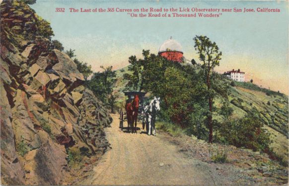
ADOLPH T. HERRMANN. The subject of this biographical sketch, Mr. Adolph T. Herrmann, the well-known civil engineer and land surveyor, a Deputy United States Surveyor, and senior member of the firm of Herrmann Brothers, was born in Hanover, Germany, in 1839. He received his education in an agricultural college in Germany, studying land surveying and civil engineering incidentally. Leaving Germany in 1859, he spent some time in the Sandwich Islands, having charge of an estate in the island of Kanai, the most westerly and beautiful of the islands. He came to San Francisco in 1860, but as he contracted a chest disease there he remained only two years, returning to the Sandwich Islands. February 8, 1876, the contract for construction was let to E. L. Derby, at the following price: Grading, $6.97 per rod; rocking (where suitable rock is found in the cut), $1.53 per rod, and where suitable rock is not found in the cut, $3.77 per rod; bridge at Smith Creek, $1,797. By May 22, 1876, the sum of $45,115.34 had been paid on Derby's contract. The board of supervisors was dissatisfied with Derby's operations, and on October 5, 1876, the board assigned Drinkwater and Swall as superintendents. On January 9, 1877, there was an official "inspection" of the just-completed road, and about 5000 visitors climbed to the summit of the mountain that day. The road was declared fully completed, the total cost being $73,458.88 [reference 4]
The Mount Hamilton Stage Company
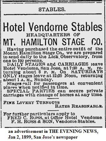
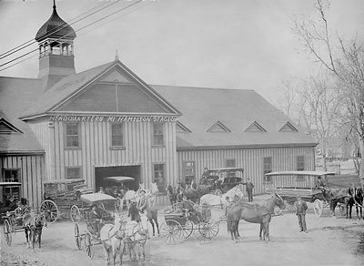
A short time ago (1888) Messrs. F. S. Chadbourne, the wealthy furniture dealer of San Francisco, San Diego, and Portland; A. H. Boomer, of the California, Oregon, and Idaho Stage Co., and S. D. Brasto, Division Superintendent of Wells Fargo & Co.'s Express, anticipating that the site of the observatory would be a tempting place of resort to the public, formed a corporation called the "Mt. Hamilton Stage Co." for the purpose of establishing a superb line of stages between San Jose and that point. Mr. Chadbourne was elected President, Mr. Boomer, Vice-President, and Mr. Brasto, Secretary and Treasurer. A. W. Ingalsbe was appointed local agent for San Jose, and Jo. Bacon assistant agent. The company sent out agents to purchase the best horses for stage service to be found on the Pacific slope; placed an order for twelve eleven-passenger coaches, constructed in such a manner as to afford to each passenger an outside seat, and began the erection of post-houses, stables, etc., on the route. They sounded the country also for old and experienced stage-drivers, whom they uniformed in corduroy suits and broad-brimmed stage- drivers' sombreros. Tally-ho coaches are also being built, hung very low, which, when completed, will be preceded by a bugler to announce the special points of view, stoppages, etc.
Original Route Went Up San Felipe Roadfrom John Nielsen, who's Great-Great-Great Grandfather Owned Halls ValleyThe first ranch on San Felipe Rd, called San Felipe Ranch, is still owned by Dave Packard and others. It is a large plot of land stretching from San Felipe Rd on the west, Grant Ranch Park on the north, and east to the ridge line going south from Mt Hamilton. Who knows how far south it goes, maybe 40,000 acres. Just east of the Mt Hamilton ridge line is the Isabel Valley Ranch, 13,000 acres. IV Ranch goes from the ridge line on it's west side, across Isabel Valley to the next ridge line, and goes north to the San Antonio Rd. I have been on the IV Ranch many times, in all seasons. It is a beautiful property, full of lakes and meadows. Some friends used to own it. I have lost contact with the current owners. Six years ago, I had permission to mountain bike ride the old San Felipe Rd, through the ranch and up to Grant Ranch Park. It is about 12 miles long and climbs about 700 feet. The route still exists as a ranch access road with many wire gates on it and steel gates to get into Grant Ranch Park. I never did the bike ride to Grant Ranch; the next Spring was wet and muddy. By the time it dried out, it was too hot. This route used to be the only way to Mt Hamilton when the original telescope was being built, finished in 1887. This route had no big hills until you got to Grant Ranch, then you started the climbing. The current route, we call Mt Ham Lower, was opened about 1900, when grading equipment got better so they could carve the road into the hillside better. I know, because my 3 X great grandfather owned the Grant Ranch (then called Hall's Valley) at the time and hauled the telescope parts to the top of the mountain with a six horse team and wagon. The first day he hauled from the train depot in SJ to his ranch house in Hall's Valley, now containing Grant Ranch Park. The second day he hauled up to the top of the mountain. Can you imagine handling a six horse team and wagon up those roads? It is hard to get a Hummer up there now.
-John Nielsen
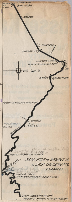
There is a map in the observatory. It showed the original route went
up San Felipe to Smith Creek.
A Bike Ride to Lick Observatory in 1914, by Charles Fullerfrom Fuller Scrapbook
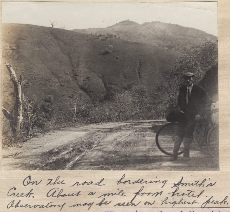
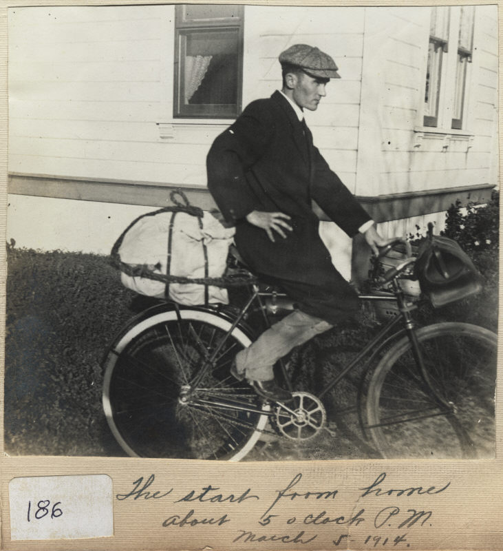
On Friday March 5, 1914 I decided to take advantage of the bright moon-light nights and spend a week-end at Mount Hamilton and Lick Observatory. I planned to start at one o-clock but about that time the preacher, Dr. Thos. M. Patterson called and insisted that I do some duplicating and typewriting for him in preparation for a musical program to be held the following Sunday night. This work took me until two:thirty o-clock and by the time I got packed up and had purchased a new tire for my wheel it was nearly five o-clock. I therefore decided to ride my wheel all the way from Sunnyvale, rather than to wait for a local train as far as San Jose.
My baggage consisted of an oil-cloth tent and a poncho sleeping bag of similar material, a large overcoat to wear nights in lieu of combersome army blanket, a small pillow, a hair rope, two gunny sacks to act as an insulator in connection with the rubber blanket, a pair of woolen socks, and several other articles all of which I put into my white canvas duck clothing bag. My culinary department was placed in a leather hand satchel and consisted of an improvised broiler, a frying pan, a kettle, granite pan, knife, fork, spoon, cup, salt and pepper shakes together with the following provisions, six potatoes, some bacon, butter, bread, cookies, graham crackers, tin of nabisco, can of sardines, half dozen oranges, sack of walnuts and almonds, also some milk chocolate, which proved to be more than a sufficiency.
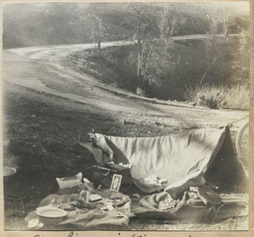
I arrived at San Jose at six o-clock and after purchasing a pack of films for my camera started for the climb. I found after 15 minutes that the road was so steep that I could not ride wheel, so had to lead it. I thus walked in the moon-light steadily until mid-night. Being fatigued by the continous seven hour exertion I decided to camp for the night near a small streamlet at one of the three hundred sixty-five turns in the road. I found upon consulting my guide book that I had traveled twenty-six miles from Sunnyvale and still had nine miles before me if I followed the road to the summit. During all of this mountain climb I found that I had the complete right of way with the exception of one auto and one wagon which passed me during the evening. Rather of a quiet moon-light stroll, to be sure. After eating a hearty mid-night lunch I went to bed in my tent and did not get up until seven o'clock the next morning, and was surprised at the beautiful panorama view of the valley below me. While I was cooking breakfast two boys who said they were from Los Gatos passed my camp. They admired my equipment and thought it could scarcely be improved upon. They said they saw me pass their camp during the night. They simply used blankets laid on the ground. They also had well fitted knap-sacks strapped to their shoulders. They said they would see me at the observatory later in the day.
The janitor was very kind and showed me the grounds and explained the nature of the different views obtained in every direction. The weather was clear so that the snow-capped Sierra Nevada mountains were plainly visible. He showed me the location of the entrance to the Yosemite Valley. Our own Santa Clara Valley looked like a relief map, with San Jose about four inches square. I could not decide the exact location of Sunnyvale.
About 7:30 in the evening all the visitors were permitted to look through the telescopes. The twelve inch telescope gave us a splendid view of a section of the moon, while the large thirty-six inch telescope was focused on the planet Saturn and its rings. All was explained in an interesting manner by the Proffessors. One said that if we were to look at moon through the largest telescope it would bring it to within sixty miles of the earth. This is scarcely believeable. As visitors are not allowed to remain in the vicinity of the observatory reservation, it was necessary for me to return to Smith Creek for the night. I again followed the trail and ran nearly the whole distance reached the hotel in practically the same time as the autos which went around the road. I camped on a high bank overlooking the creek and hotel.
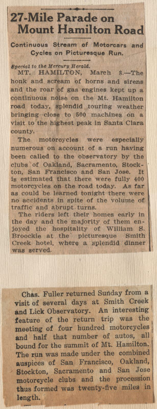
Was disturbed in the morning by the pop pop pop of motorcycles. It was 4:30 and from that time until noon there was a continuous procession of machines all bound for the summit of Mt. Hamilton. The run was made under the auspices of the motor clubs of San Francisco, San Jose, Stockton, Sacramento and Oakland, and the procession thus formed was thirty miles in length. As I had to be home by evening to assist in the musical program at the church, I reluctantly left my beautiful surroundings at Smith Creek and in three hours was at San Jose. It was almost a continuous coast for the whole distance, and was quite exciting. Only took two headers resulting in slight bruises. The weather again broke the record of many years for excessive heat for the time of year, never-the-less it was a delightful experience. Hope I can go on a similar excursion soon.
Mount Hamilton Road today
References
|
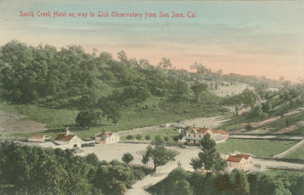
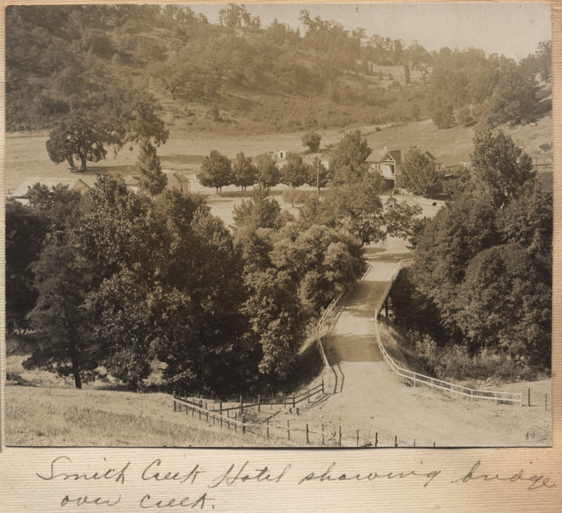 I resumed my journey about 9:45 A. M. and arrived at Smith's Creek Hotel an hour
later. Had lunch at this hostelry, and after a short rest "hit the trail" for the
summit. I saved about four miles by following the telephone poles instead of
following the road. The weather was hot, thermometer registered 85 degrees, and
the trail was steep, and was therefore the hardest mountain climb I had ever
attempted. During that two miles I climbed from an altitude of 2100 feet to that
of 4209 feet so about 3:30 P. M. when I reached the summit I was mighty glad.
The janitor of the observatory saw me when I arrived and took my picture as I
touched the building.
I resumed my journey about 9:45 A. M. and arrived at Smith's Creek Hotel an hour
later. Had lunch at this hostelry, and after a short rest "hit the trail" for the
summit. I saved about four miles by following the telephone poles instead of
following the road. The weather was hot, thermometer registered 85 degrees, and
the trail was steep, and was therefore the hardest mountain climb I had ever
attempted. During that two miles I climbed from an altitude of 2100 feet to that
of 4209 feet so about 3:30 P. M. when I reached the summit I was mighty glad.
The janitor of the observatory saw me when I arrived and took my picture as I
touched the building.